VCE 3 / 4 Geography Notes – 96.9 ATAR
Summary:
The notes provided cover various topics related to land cover change and its implications. In Unit 3 AOS 1, the focus is on land use change, including concepts such as arable land, ad hoc development, brownfield land, catchment management authorities, covenants, desiccation, extensive and intensive land use, and more. The notes explore different aspects of land use and the regulations and practices associated with them.
In Unit 3 AOS 2, the focus shifts to land cover change specifically related to deforestation. The notes cover topics such as forests, terrestrial biodiversity, deforestation, different regions and climates, forest conservation, sustainable use of forests, and global initiatives like the Sustainable Development Goals. The impacts of land cover change, including environmental services, carbon sequestration, and nutrient cycling, are also discussed.
Additionally, the notes touch upon land cover change related to melting glaciers and ice sheets. Topics covered include the cryosphere, glaciers, ice sheets, periglacial environments, tundra, taiga, climate change indicators, erosion and deposition processes, and the effects of glacial melting on ecosystems and landscapes.
The final section of the notes focuses on land cover change related to desertification. Key concepts include the water cycle, food security initiatives like “Food for Work,” different approaches to addressing land degradation, arid and dry subhumid ecosystems, erosion, exotic species, fallow periods, and the role of organizations like the FAO.
Excerpt:
VCE 3 / 4 Geography Notes – 96.9 ATAR
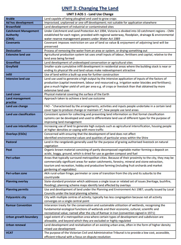
UNIT 3: Changing The Land
UNIT 3 AOS 1 – Land Use Change
- Arable: Land capable of being ploughed and used to grow crops
- Ad hoc development: Improvised, unplanned or one-off development; not suitable for application elsewhere
- Brownfield: Land development of industrial or contaminated sites
- Catchment Management Authority (CMA): Under the Catchment and Land Protection Act 1994, Victoria is divided into 10 catchment regions – CMA was established for each region; provided with the regional waterway, floodplain, drainage & environmental water reserve management powers under Water Act 1989
- Covenants: Covenant imposes restrictions on the use of land, so the value & enjoyment of adjoining land will be preserved
- Desiccation: Process of removing the water from an area or system, or drying something out


Reviews